Projects
With a rich university experiences in urban planning projects, I bring forth a robust skill set honed through extensive engagements in site analysis, navigating site development parameters, property development ventures, and the intricate realm of urban design. Each project has served as a stepping stone for refining not just technical expertise, but also a holistic understanding of integrated development planning. Through these experiences, I've cultivated a keen eye for site analysis, deciphering the dynamic interplay between space, community needs, and sustainability imperatives. Moreover, these projects have deepened my comprehension of the pivotal role urban planners play in shaping societies. It's not just about blueprints and zoning; it's about weaving together the fabric of neighborhoods, fostering inclusivity, and crafting environments that echo the pulse of the communities they serve. My portfolio isn't merely a collection of projects; it's a testament to the transformative power planners wield in sculpting the landscapes of tomorrow.
Concept Development and Township Layout
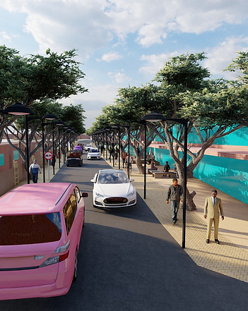
Chosen Project Name: Feet First Cental
In the heart of Kagiso, Johannesburg, an ambitious urban revitalization project emerged, meticulously designed to reshape the cityscape while addressing crucial societal needs. Grounded in the consultative wisdom of Mogale City's Land Use Scheme, this endeavor embarked with a comprehensive feasibility study. The project's objectives evolved in response to the study's findings, ensuring a strategic alignment with the community's demands and the city's developmental trajectory.
Adhering to robust urban design principles and leveraging existing precedents, our approach laid a robust foundation. We navigated the intricacies of zoning intricacies and land use restrictions adeptly, seamlessly integrating 500 affordable dwelling units into the fabric of the community. Diverse building typologies were ingeniously employed to fulfill this mandate, enhancing socio-economic diversity and inclusivity.
A cornerstone of our design philosophy was the creation of a pedestrian-friendly environment, fostering connectivity and a vibrant communal spirit. The resultant township establishment isn't merely functional; it's a testament to our commitment to holistic urban living. Through meticulous planning and execution, I transcended blueprints, presenting vivid 3D renderings that encapsulate the visionary essence of our concept
Property Development for Planners
Reflecting on one of our previous urban planning project focusing on the revitalization of Johannesburg's iconic Carlton Centre, my team delved into the theoretical realm while emphasizing real-life implications. This endeavor was more than a theoretical exercise; it offered a tangible glimpse into the complexities and challenges inherent in urban development projects.
Our approach centered on comprehensive Real Estate Market Analysis, scrutinizing supply and demand dynamics. We navigated the intricacies of development and management processes, acknowledging the multifaceted nature of revitalizing a 50-storey skyscraper. This involved a deep dive into investment analysis, feasibility studies, and the intricate web of financing within the property sector.
This project was a testament to our ability to blend theoretical knowledge with practical applications. It allowed us to grasp the nuances of urban planning and property development, preparing us to navigate real-world challenges. The Carlton Centre's revitalization demanded a holistic understanding of economic, social, and environmental factors—an invaluable lesson for any urban planning endeavor.
Our insights into the revitalization project equip us with a nuanced perspective and a comprehensive skill set. We are primed to contribute meaningfully to similar projects, leveraging our understanding of market dynamics, development processes, and financing intricacies to drive impactful urban transformations.

Indawo Diaries
Chosen Project Name: The Horizon of two economies
Undertaking a spatial analysis project encompassing the contrasting dynamics between Oxford Rd in Rosebank Johannesburg and Wanderers St in Hillbrow Johannesburg was a profound exploration into the nuanced fabric of urban landscapes. Oxford Rd stood as a bastion of a formal economy, boasting prominent retailers and established commercial entities. However, its disposition was marked by a stringent allocation of spaces, evidenced by restricted access and delineated areas.
Conversely, Wanderers St pulsated with the vibrancy of an informal economy, adorned with bustling street vendors and a lively taxi rank. This thoroughfare, in stark contrast, embraced a more fluid appropriation of space, fostering a diverse array of activities and adaptable areas.
The disparities in spatial utilization were conspicuous: Wanderers St was a canvas where multiple functions intersected harmoniously, embracing a myriad of uses within its domain. It seamlessly integrated residential elements amidst its mixed-use landscape, creating a dynamic environment where livelihoods intertwined with living spaces.
The project illuminated the intrinsic link between spatial design and societal dynamics, underlining the significance of flexible spatial planning in accommodating diverse economic and social activities. This immersive analysis provided invaluable insights into the intricacies of urban spaces, laying the groundwork for informed, inclusive, and adaptable urban planning strategies crucial for any prospective urban development endeavor.
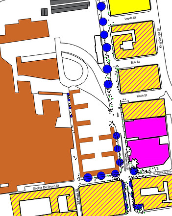
Corner to Corner
Chosen Project Name: Kwadunusa
This project was centered on spatializing demographic data, we undertook a transformative approach to translate intricate statistics into a visually cohesive and comprehensible form. Recognizing the limitations of traditional tables and graphs in conveying the nuanced narrative of demographic information, we delved into a method that transcended conventional formats. Embracing the power of sketches and diagrams, we orchestrated a visual symphony where data points harmonized with spatial elements, breathing life into statistics.
The critical aspect of this endeavor lay not merely in the depiction of data but in ensuring a consistent graphic format. Consistency became the linchpin, enabling seamless interpretation and fostering an intuitive understanding of complex demographic insights. Each diagram and sketch was meticulously crafted, not just as an isolated representation but as a part of a larger narrative, where every visual cue contributed to a holistic understanding of demographic patterns.

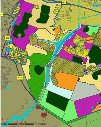
Spatial Development Framework
Embarking on the Spatial Development Framework (SDF) for Kagiso, Johannesburg, was a multifaceted endeavor that included a number of factors like environmental, economic, and social dynamics. The assessment phase delved deep into the area's essence, revealing a landscape shaped by the dominant industries of mining and smallholding farming, juxtaposed against challenges of informal settlements devoid of adequate service delivery. The intricate interplay of a wetland traversing the region and populations residing on floodplains added layers of complexity to the canvas I navigated.
Drawing from these insights, the project took shape through meticulously crafted objectives that metamorphosed into a transformative SDF. Addressing housing backlogs and the imperative for housing expansion emerged as pivotal factors, woven seamlessly into the fabric of the proposed framework. It was not solely about architectural blueprints but about reimagining the very essence of the community.
The resultant SDF stood as a testament to empowerment across environmental, economic, and social dimensions. It didn't merely outline plans; it was a roadmap for sustainable growth, fostering resilience while honoring the area's heritage.
Blog Assignment (Research)
Chosen Project Name: The Politics of Taxi Routes
Within the bustling tapestry of global south cities, the labyrinthine network of informal taxi routes has organically morphed into a multifaceted phenomenon extending far beyond mere transportation. Embarking on an illuminating journey, this blog project seeks to unravel the intricate connection between these unregulated transit pathways and the political landscape. With a lens focused on the dynamic urban landscapes of Lagos, Quito, and Nairobi, the project ventures into a comparative analysis that unveils the intricate interplay between these cities' informal taxi networks and the realm of politics.
Through meticulous exploration, it delves deep into the pivotal role these ostensibly ordinary routes play as epicenters for political maneuvering, contention, and at times, even violence. Their influence transcends the domain of transportation, leaving an indelible mark on the evolution of residential and commercial spaces within these urban ecosystems.
Each city encapsulates a unique narrative, weaving a story of how these informal routes serve as conduits for social, economic, and political dynamics, shaping the very fabric of their development. By dissecting this entwined relationship, the project aims to shed light on the profound impact these seemingly mundane pathways wield, offering insights into the complex and symbiotic relationship between informal transit systems and the broader urban landscape.

Evaluating the Relevance of the IDP
Integrated Development Plan
In navigating the realm of urban planning, the Integrated Development Plan (IDP) stands as a cornerstone, shaped not just by legislative mandates like the Developmental Facilitation Act (1995) and the Local Government Transition Second Amendment Act (1996) but by the core principles it embodies: social justice, equity, and integration.
Delving into the intricate fabric of the IDP, we've encountered its paradoxical nature. While revered as a blueprint for holistic development, flaws lurk within its structure. Its sheer breadth sometimes leads to overwhelming complexity, occasionally obscuring its primary purpose beneath layers of bureaucratic intricacies.
Yet, despite these imperfections, the IDP remains a pivotal tool in the urban planner's arsenal. Its resilience lies in its adaptability, its capacity to evolve alongside the ever-shifting landscapes of cities and communities. It endures not merely due to legislative mandate but because, at its essence, it resonates with the foundational aspirations of society—to create spaces that embrace diversity, ensure fairness, and foster sustainable growth. The IDP's longevity lies in its ability to serve as a platform for dialogue, a catalyst for community engagement, and a compass steering municipalities toward a future where cohesive, integrated development isn't just a goal but a lived reality.
